Transfer information for Sariyer
What to know about Sariyer before you set off: what the area is like, the road from the airport, how long the drive takes and when the traffic builds up.
About the area
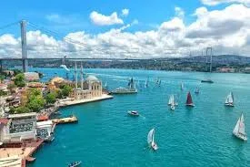
Sarıyer covers the northern part of the Bosphorus's European shore and is one of the city's greenest districts, with former fishing villages, waterside mansions and woods. The fish restaurants and small hotels along the shore are popular for weekend getaways, while villa estates and schools fill the inland areas. It suits travellers who want a quiet stay by the water, away from the crowds, and don't mind the distance to the city centre.
Roads, drive times and peak hours
The car crosses the Bosphorus from the TEM on the Fatih Sultan Mehmet Bridge, drops down from its European end to the coast road and follows the shore north to Sarıyer. The 52 km drive takes about 55 minutes in normal traffic. The road along the Bosphorus is narrow and sensitive to traffic; progress slows noticeably on weekdays between 07:30–09:30 and 17:30–19:30, on Friday evenings and on fine weekend afternoons. The district stretches a long way from north to south, so naming the neighbourhood you are going to (for example Tarabya, Yeniköy or Rumelifeneri) makes it easier to estimate the journey time accurately.
The distance and drive time come from the same route data as the price on this page and assume normal traffic; how busy the roads are depends on the season, the day and the hour. Last checked: